From wind to snow
Strong gusts damage trees, buildings; blizzard conditions in forecast

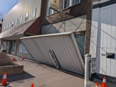
Photo by Mike Lamb The metal awning at the entrance of the Orphanage Antiques in Marshall fell down Thursday night, presumably from the high winds reported across southwest Minnesota.
MARSHALL — Randy Peterson was in for a surprise when he came to Orphanage Antiques on Marshall’s Main Street on Friday morning. The metal awning from the front of the business was down on the ground – evidently a victim of Thursday night’s strong winds, he said.
“It looks like it tore apart from the building,” Peterson said. “It’s been up there a long time, and we never had any problems with it before.”
Peterson said the fallen awning didn’t damage the store’s front windows. But he was waiting to hear from the Marshall city staff on what to do about the awning and the building.
High winds Thursday night left a mess in places around Marshall – and the region is in for more severe weather this weekend. The Marshall area will be in a winter storm watch from Saturday evening through Monday morning, the National Weather Service said. Snow accumulations could be anywhere from 9 to 15 inches, with winds gusting as high as 50 miles per hour.
Wind gusts Thursday night were already extreme, according to local storm reports on the NWS website. Gusts of 73 miles per hour were reported south of Canby on Thursday night. Winds also reached miles per hour or more near Redwood Falls, Tracy and Taunton. A wind gust of 78 miles per hour was reported in Florence around 2:55 a.m., the NWS website said.
Wind gusts of 64 miles per hour were reported at the Marshall airport around 1 a.m., the NWS said.
Marshall Parks and Recreation Superintendent Preston Stensrud said city crews had a lot of cleanup work to do Friday.
“We’ve been working all morning,” Stensrud said. “We’re going to try and get everything picked up.”
Damage included a lot of downed tree branches, but the wind also knocked down construction fencing at the new Marshall Aquatic Center site, and damaged fences near Legion Field Park. Stensrud said there were also instances of stop signs bent by the wind near the Red Baron Arena and Expo.
The potential for severe weather continues through this weekend. The NWS said areas of light snow were forecast to start Saturday morning in the region, but the real risk for heavy snow comes Saturday night through Sunday. Snowfall totals exceeding 6 to 12 inches will be possible in parts of the region. Strong winds are also forecast to develop Sunday, which could cause blizzard conditions.
The uncertainty over the weather caused concern for Lucan residents, who had been planning the community’s annual St. Patrick’s Day parade and festivities on Sunday, said business owner Anna Knott.
“Nobody knows if it’s going to be eight inches or 16 inches (of snow),” Knott said. Factoring in strong winds and temperatures in the 20s, things didn’t look good for the celebrations, she said.
Organizers of the parade announced Friday that they would be postponing the St. Patrick’s Day parade until March 22.
“It’s a total bummer, because last weekend it was 60 degrees out,” Knott said.
Local News
Motorists brace for rising gas prices
MARSHALL — Motorists filling their vehicles on Friday reacted to prices at Marshall gas stations reaching $3.59 ...
From wind to snow
MN Farmers Union to host People’s Town Hall
SLEEPY EYE — The Minnesota Farmer’s Union (MFU) hosts a People’s Town Hall at Sleepy Eye Brewing Wednesday, ...

‘I can succeed’
Wintry weekend possible for St. Patrick events
MARSHALL — As southwest Minnesota faces a winter storm watch, area communities are still planning weekend ...